Wednesday, March 08, 2006
Hansen Creek Quartz Crystals
 Open Property?
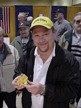
Last year I developed a 'hankering' for small, perfect quartz crystals. I gave up my quest for large, thumb-sized honkers and concentrated on well-formed, nicely-terminated clear miniatures. The object of my current desire is located on Hansen Creek, along I-90 outside of Seattle, Washington.
The Hansen Creek site is well-known to Pacific Northwest crystal-seekers. Bob Jackson mentioned the locale in volume 4 of his epic series "Rockhound's Guide to Washington" which is out of print and hard to find. Here's some of what Bob had to say back in 1992:
"I think every crystal collector in the Northwest has been to Hansen Creek to search for amethyst scepters. In the 12 years since I first published the locality, the scepter area has gone from having a few piles of screened dirt along the roadside to hundreds of major excavations, some large enough to park a Volkswagen underground! Yet it seems most everyone has stayed within the boundaries of the traditional areas, now administered by the Mineral Council. Less than a mile from that locality are two others which produce strikingly different quartz crystals, including Japan Law twins."
Said another collector on the Rock-Net discussion board:
"Have you been to Hansen Creek? It is on the west side of the I-90 pass. It is on the south side of the road by Denny Creek exit. One and a half miles in to the trail and one and a half miles up the trail, it can be driven with a pick up. There are about 200 holes in the side of the mountain, pick one or make a new one. The Mineral Council does not mention this dig because people tunnel under old Doug fir stumps and make caves, dangerous! You can fill your pocket in a day’s dig, with the best crystal being the size of your little finger, or you may get better! All colors depending where you dig. The Mineral Council has a map for sale for 6 bucks which has 20+ DIG SITES IN IT. Go to Washington State Mineral Council for a list of trips. (From joelzpol - June 14, 2005 at 10:48:52])
[Cite: http://www.rockhounds.com/rocknet/messages/37938.shtml
Compare that optimistic paragraph with this note posted by Chris Rylands in 1998 on his Washington State Rockhounding site:
"The Hansen Creek collecting area has been closed to collecting permanently. This closure is to take place immediately (8/15/98). The Washington State Mineral Council (WSMC) has dropped its claim in the area and is strongly recommending that no further collecting take place. There are two other claimants in the area and they will not allow the public to collect without permission.
"A number of recent incidents have precipitated this action. The latest incident involved two individuals who were collecting crystals and were "bugged" by the numerous mosquitoes and biting flies that are always present. In order to keep the bugs away these idiots decided to start a fire in the area in which they were digging. As anyone living in the Seattle area knows the last several weeks have been very hot and the fire danger in the forest is extreme. Someone noticed the smoke and within a very short time the King County Sheriff's department, the Fire Department, the Forest Service, and several other emergency vehicles were descending on the Hansen Creek area. After about an hour of bushwhacking through the undergrowth, the culprits were confronted and the fire extinguished.
"It is due to this sort of irresponsible behavior by these "crystal freaks" that the WSMC has decided to drop its claim and recommend that the area be closed to collecting by the general public. Anyone witnessing illegal mineral collecting at Hansen Creek is advised to report it to the North Bend office of the Forest Service at 425-888-1421. Once again the stupid acts of a few individuals have ruined another popular collecting site. "
[Cite: http://www.washington-state-rockhounding.info/Trespass-index.htm]
Well, I got to poking around and contacted Robert O'Brien at the Mineral Council. Here are the contents of his March 9, 2006 email, although I edited very slightly:
"For digging at Hansen Creek there is a long and sometimes gory history. The initial crystal areas were found when the road cuts were being put in. Since the crystals are in a slump (slide) zone on the shoulder of the mountain, Bob Jackson passed the info on to the Mineral Council and a placer claim was filed. The reason Bob passed the info on was because he saw no real economic value to the crystals vs. the labor to get them and the amount that can be collected. On one of the field trips, one of the people, Higley, saw an opportunity to take the claim away by calling it a Lode Claim. He then filed on it as such.
"Also another group filed on the upper road (Zeckster). The Mineral Council battled with Higley over the right to collect crystals and the validity of the claims was questioned several times. In the meantime, other people continued to enter the area and collect crystals. There were many large holes dug and at one point you could see one of the holes from the freeway as you drove by. The Forest Service started making noises about reclaiming the area and the Mineral Council, which was about bankrupt, decided that it was not feasible to the members to task them with a bill for reclamation, especially when most of the digging had been done by others who had no connection to any rock clubs. Thus it was decided in a full Mineral Council meeting to officially relinquish any claims in the area and declare the area closed as a rockhound site.
"THAT DOES NOT MEAN THE AREA IS LEGALLY CLOSED
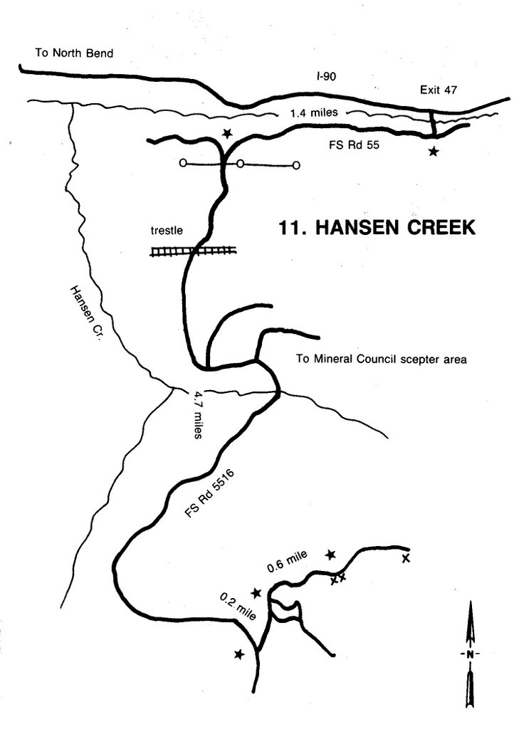
"The Forest Service has always stopped just short of saying it is closed. Currently as soon as the snow goes away people still go up there and collect. The access is still pretty good. Basically you drive east on I-90 to Exit 47... At exit 47 you turn to the right and go about 1 block. The road intersects a "T" and you turn right again.... You are now heading west on a well travelled dirt road. After about 2 miles there is an intersection with a road to the left. You will turn on this, so you are heading south and up a canyon..You will go under the trestle and about 1/2 a mile past that you will see an overgrown road to the left. You would park there and walk down the road approx 1/2 mile again. Near the end of the road it degrades into a trail and from that point on crystals can be found on the uphill side in the dirt. About 5 - 10 % will be amethyst.
Good luck
Bob OBrien"
OK! So now I'm feeling pretty good about this trip. I'm thinking I need some geological information, so from MinDat and http://www.washingtonminerals.com/hc.htm I pulled the following together about the Snoqualmie Batholith:
"Snoqualmie Batholith - Miocene (20 Ma). Uplift and erosion of the Old Cascade Volcanic Arc exposed plutonic rock of the Snoqualmie Batholith near Snoqualmie Pass. Intrusive rock types found within the Snoqualmie Batholith range in composition from granite to gabbro. Granodiorite is the most prevalent exposed rock type. Other lithologies within the batholith include porphyritic dacite, andesite, aplite, and intrusive breccia (Livingston, 1971).
"Intrusive breccias can be the host for metallic ore deposits and aesthetic mineral specimens. An intrusive breccia is a cylindrical structure that is formed by the violent ascent of volatiles near the top of a shallow intrusion as it cools. The force of volatiles escaping to the surface causes the rock to fracture and fault, providing open spaces for subsequent mineralization by hydrothermal fluids. These high temperature acidic fluids are responsible for the alteration of plagioclase to muscovite and clay within the adjacent granodiorite breccia blocks and for the precipitation of quartz and metallic ore (usually as sulfides) on the walls of the blocks. Most intrusive breccia metallic mineral deposits within the Snoqualmie region are currently uneconomic due to poor accesibility and/or the low tenor of the ore (Cu, Au, Ag), but many mining claims are still active that produce some of the finest quartz and sulfide mineral specimens in the world.
"Mineral localities within the Hansen Creek area are either breccia exposure or slump zones derived from breccia. There are a number of collecting areas existing within a relatively small area that comprise the Hansen Creek locality. Some are privately claimed. The claim owners do not allow collecting."
Well, it sounds like there is plenty of opportunity to poke around without trespassing. My tentative plan is to head up the weekend of April 14. We'll see how lucky I get.
Tuesday, February 28, 2006
Great Gravel!
February 25th turned out to be an excellent day to mount an expedition on the beach gravel deposits at Road's End, just north of Lincoln City, Oregon. Although I had visions of visiting several other locations, this was the extent of my collecting for the weekend.
It turned out better than I thought. The sands were completely washed away in many places, exposing Astoria Formation bedrock for 200 yards leading north to the headland at Road's End. The Miocene-aged Astoria bed are tilted at about a 40 degree angle here, and sit unconformably against basalt and basaltic stacks that are highly resistant. The first igneous rocks look like a pyroclastic hodge-podge of angular clasts cemented into a dark host, but further out into the waves the rocks are stricter basalt, dark and dense.
Once past the headland, there is a small cove that on this day was covered with gravels. Usually the bulk of the gravels are little pea-sized rough, but this day there were cobbles piled up in places. Several stretches of big pebbles filled in the holes. Sand, mercifully, was almost hidden from view.
The pickings were excellent right away. I found agates, both red and green jasper, and some nice yellow-red jasper that I know from experience takes a good polish. I didn't find any bloodstone -- green jasper with red spots -- but I found much more petrified wood than usual. I also picked up some good agates that were trending in the direction of carnelian. In about 75 minutes I had about ten pounds of rough, and it won't take a month on the biggest grit to get it smoothed out.
I highly recommend this spot. The kids can play in the tide pools and toss rocks in the waves, the abundance of good tumbling material is staggering, and it's a bit of an adventure to get in there.
Friday, February 24, 2006
Oregon Beach Agates
Hoping For Storm Damage
From my vantage point in Beaverton, Oregon, there have been a lot of Pacific storms this season. Hopefully, that will result in washing several feet of sand off the prodigious beach gravel deposits I like to haunt. For the last two years, the pickings have been slim.
I checked in with Lee at Pier Avenue Rock Shop in Tierra Del Mar, just north of Pacific City. I first visited his rock shop last year and found him to be a knowledgeable dealer with experience ranging from agates to zeolites, from Oregon to points well beyond. He had some nice petrified wood from Succor Creek in his front yard, and some beautiful faceted sunstones in the display case. Lee is at http://www.pieraverockshop.com/index.html and you can contact him through there.
Lee told me that the storms had indeed moved off the sands, so he invited me to stop by and have a chat. He also told me about the so-called "Thunderstorm jasper" being marketed on eBay by Western Oregon Lapidary Source in Tillamook. He wasn't sure if this material was being created by recent rockslides at Cape Meares and Cape Lookout. He said both of those were still productive, but I'm leary about driving that far north from Lincoln City when I can just hunker down at Road's End.
If you've never been there, Road's End is at the north end of Lincoln City, Oregon. You drive past the casino, around the big curve, then past the wayside and up to the final parking spot. It's hard to find among all the vacation house driveways, but just go slow and you'll find it. From there, you step onto the beach and proceed north toward the big rock.
Two interesting points for fellow lithophiles. First, the beach is covered with streaks of black sand. This is not oil residue from the leak of the Exxon Valdez, nor bilge sludge from the wreck of the New Carissa. This is honest-to-god black sand, chock full of magnetite, ilmenite, platinum, rare earth elements, and gold. I've collected it and panned it, and I've gotten microscopic colors. The deposits have either come up from the south, such as famed Gold Beach, or down from the mouth of the Columbia, which drains the Snake River (Boise Basin) and the John Day River (Baker, Sumpter). It's fun to collect. I usually take a water bottle and fill it with black sand on the hike back.
The second treat is a limy concretion known as the Indian marble. They're small -- like marbles -- and are eroding out of the sandstones that abut Road's End. Some are the size of a baseball, and some are extremely round. They're very plentiful. I've never cracked one open to see what's inside, but then I got spoiled by the big stuff out by Vernonia where crabs and rock lobsters have been found.
Anyway, it's about a half mile to the rock at Road's End. You'll find numerous tide pools where the beach ends, and if you weren't looking for it, you'd never know that you can circle around to the north to a small, secluded cove. On a good day, you'll find loads of gravel there. On a bad day, you are going to find small gravel mounds. You never really know what you'll find.
The hike in there can be a trial. Some days, the sand is piled up flat like a super highway, and the walk at low tide is easy. Some days you have to scamper over a rocky spine that has barnacles and purple, slippery seaweed. My Golden Retrievers have made the trip along that spine numerous times, but it isn't something I'd take Grandpa along for.
The size of the gravels at Road's End is not spectacular unless you get a really nice low tide. Usually, you're working with a half-inch in size or smaller. But the quantity makes up for the size, and the quality pushes it over the edge. There is a good variety as well. I've found petrified wood, red jasper, a nice green jasper, plus white agates, crystal clear agates, carnelian, and more. The sand content of the beach ensures that the rocks are very polished, so you can tell instantly if something will take a good shine. I haven't found any fossils here, but I do consistently find beach-polished glass, especially green.
Treasure is what you make of it, of course. The dogs found a dead baby deer that had apparently tumbled down the cliff. These are the same dogs that couldn't be stopped from rolling in a dead fur seal they chanced upon. The car smelled awful for weeks after that event.
The bounty of Road's End is astonishing. There have been times when I simply lay on my side, with the sun in my face, and picked through the rocks within reach. One time, I made a "rock angel."
The cliffs up from the beach are steep, but not so steep that my son and the dogs couldn't climb up for a view. You want to make sure that you skedaddle out by the time the tide starts coming in strong, because you don't want to scramble across the big boulders in a hurry to get out. But most people have enough sense to watch for the shifting tide. To be sure, you should also check the tide tables at the OSu Hatfield Marine Science Center at http://hmsc.oregonstate.edu/weather/tides/tides.html.
I usually bring a plastic baggie for my treasures. I tried just using my pants pockets but the load almost pulled my pants down on the trip home.
To wind down, I recommend the India Pale Ale at the McMenamin's Lighthouse Brewpub back by Highway 101. It's family-friendly and they don't mind if you track in a little sand.
![]()